Crested Butte Land Trust
The Crested Butte Land Trust (Land Trust) was founded in 1991, when a group of local residents recognized that Gunnison Valley’s cherished landscapes were at risk- and that if lost, the character of our community would be threatened. Twenty-seven years later, the Land Trust has matured into the only nationally accredited land trust in Gunnison County.

The Organization and Mission
The Crested Butte Land Trust (Land Trust) was founded in 1991, when a group of local residents recognized that Gunnison Valley’s cherished landscapes were at risk- and that if lost, the character of our community would be threatened. Twenty-seven years later, the Land Trust has matured into the only nationally accredited land trust in Gunnison County.
Over time, the Land Trust has developed a unique and highly valued portfolio of conserved land, including over 1,000 acres of fee-owned land, much of which is located in the Slate River Valley. This area was identified as a premier aquatic resource, and its preservation and restoration has been a cornerstone of the Land Trust’s stewardship efforts for nearly two decades.
Three significant achievements that showcase the Land Trust’s stewardship program include; the preservation of the Slate River and its wetlands through the conservation of over 3.8 miles of river corridor and 210 acres of the valley floor and its high functioning wetlands, the reclamation of two abandoned coal mines in the Slate River Valley, and the Peanut Lake Restoration Project, which in 2015 protected the 40-acre natural lake from being breached by the Slate River.
Combined, the successes of these projects have significantly improved the natural quality of the area and its riparian habitat from when it served as a gateway for coal and silver miners in the late 1800’s. Today, the Slate River Valley and its riparian habitat provide an abundance of unmatched ecosystem services, from year-round recreational opportunities to wildlife habitat and a critical floodplain buffer and natural water filtration system.
The Project
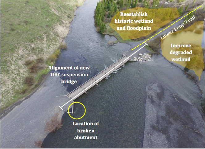
The Gunsight Bridge Replacement and Restoration Project is part two of a three phase project being led by the Land Trust. The project includes two main objectives; replacing Gunsight Bridge and installing relief culverts underneath the railroad grade downstream from the bridge. Combined, these project elements will result in a new bridge designed to interact positively with the surrounding environment and river hydrology and will enhance stream and adjacent wetland health.
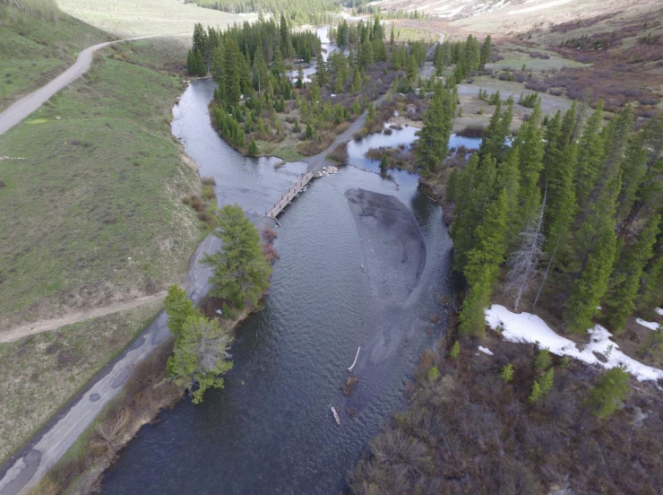
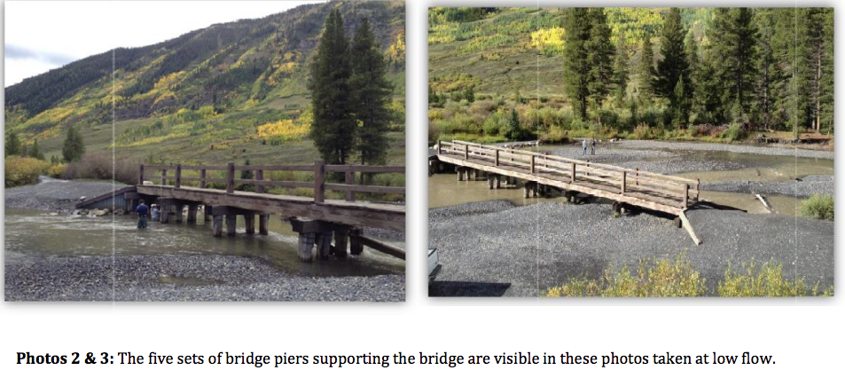
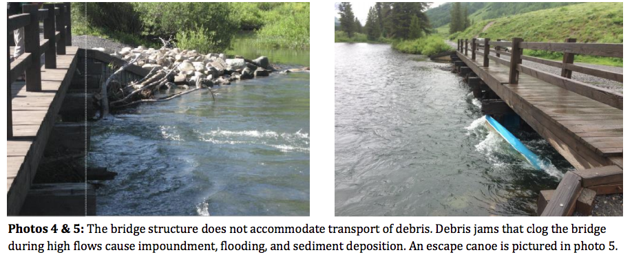
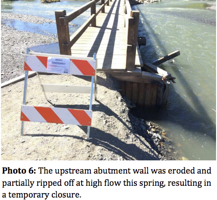
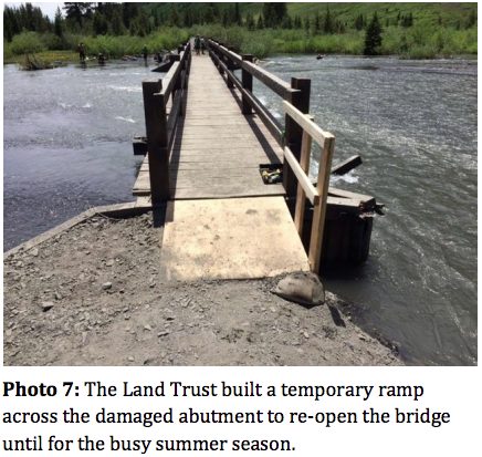
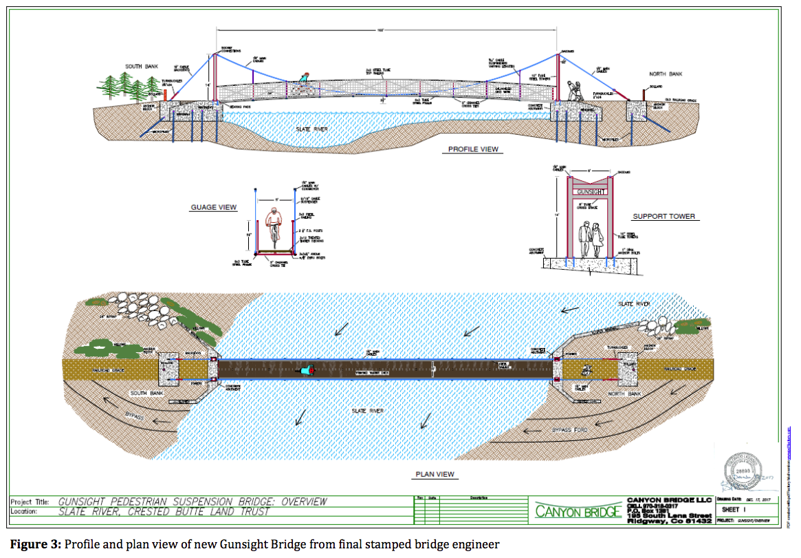
Bridge Replacement: The current and deteriorating bridge is built of wood and supported by five sets of four piers each (see photos 2&3). The piers, aligned perpendicular with the bridge span and exposed to direct flow, act as a strainer for woody debris that frequently finds its way down the Slate River during peak flows. The debris is regularly caught by the piers as it moves down river, acting like a dam and impounding water upstream (see photos 4&5). Additionally, the bridge’s 80 foot span across the river is too narrow, and constrains the river channel to an unnaturally narrow width, limiting the ability of the river to utilize its floodplain and directly exposing the bridge abutments to the erosive power of the river. To alleviate these stressors, the new bridge will be a full-river span suspension bride. Additionally, the bridge span will be increased from 80 to 100 feet to better accommodate the channel width during high flow. The removal of the in-stream piers will lessen flood risk and damage caused by sediment deposition and erosion from the impounded segment of river.
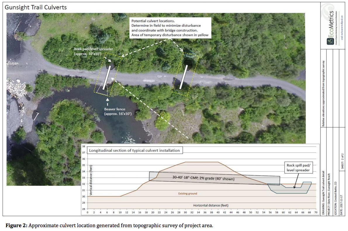
Relief Culverts: Over time the elevated trail (old railroad grade) leading to the bridge has prevented the river from flooding onto the floodplain (see Map 2). Instead, the flow is routed through the bridge opening. During high water the area upstream and to the west of the trail serves as backwater habitat. However, the area downstream and east of the trail has dried out due to the lack of connectivity to floodwater. The installation of two relief culverts underneath the trail will allow for backwater to flow freely into this area, re-establishing 0.6 acres of riparian habitat and improving 0.9 acres of riparian habitat.
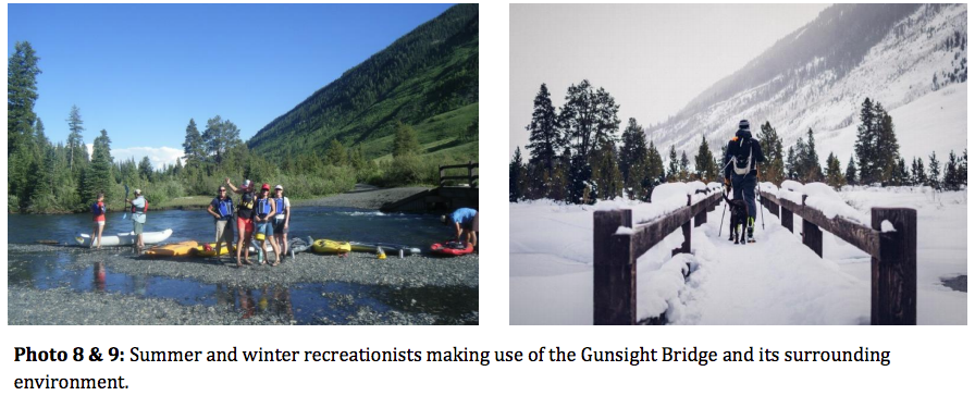
Since 2012 the Land Trust has been working towards replacing the Gunsight pedestrian bridge. The bridge, built in the early 1900’s, was part of the Denver Rio Grande Railroad and used by railcars to cross the Slate River to transport coal up and down valley. Today, it serves as a vital link in one of the area’s most heavily used trail networks, the Lower Loop.
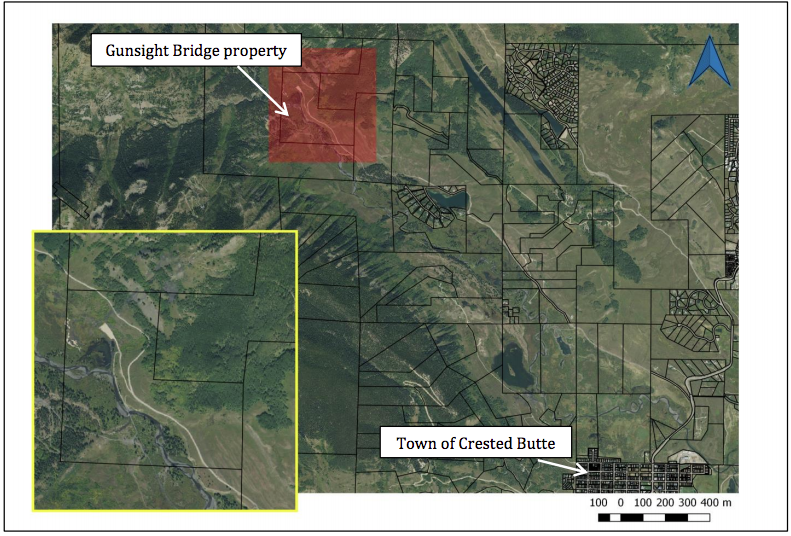
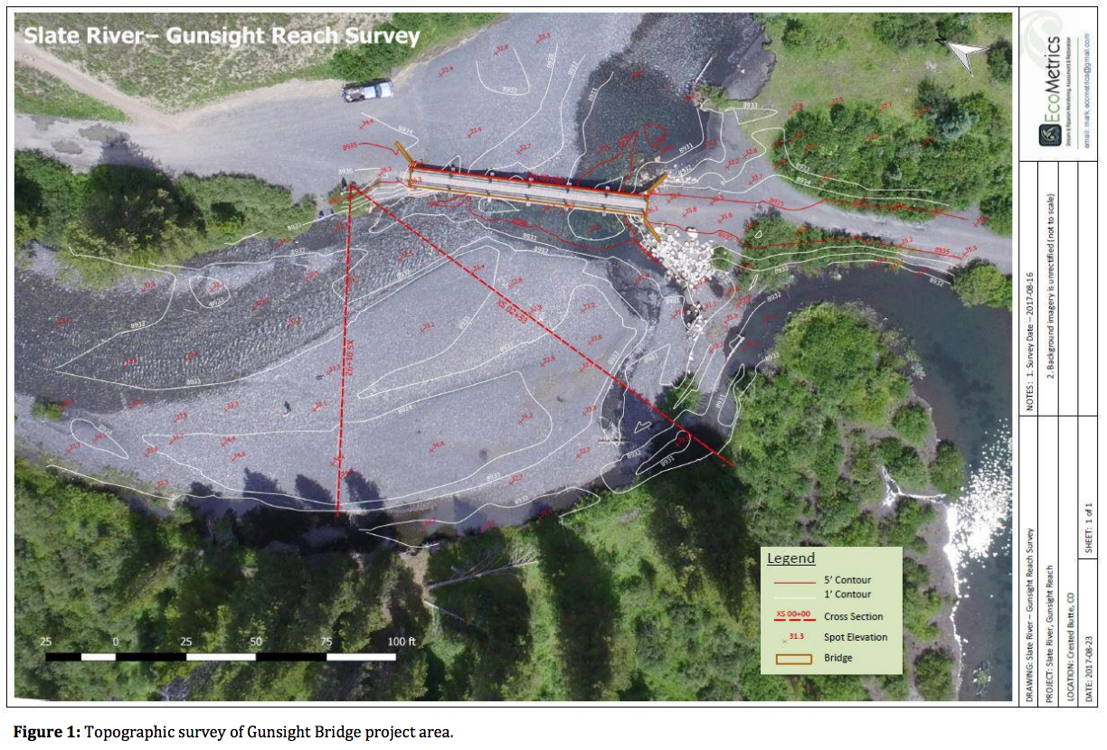
In 2012 the Land Trust, together with multiple local entities, completed a Geomorphic Assessment of the Upper Slate River Valley. Two years later a Watershed Plan was completed for the Slate River. The studies have been critical for prioritizing and guiding the Land Trust’s stewardship projects over the last seven years. These studies consistently identified the Gunsight Reach as a high concern for ecological impairment and a high priority for restoration. The Gunsight Reach is a 0.25 mile stretch of the Slate River located on the 120 acre Gunsight Bridge property that extends up and downstream of the bridge.
In 2014 the Land Trust worked closely with two ecologists to complete a Prediction Level Assessment (PLA) for the Gunsight reach. The intent of the PLA was to pursue a broad-scale assessment of the Gunsight reach to determine the impacts of anthropogenic changes to the area, and to assess the condition of the observed braided stream morphology. The PLA identified several direct and indirect human stressors affecting the Gunsight reach; the bridge being the most severe. The design and structure of the current bridge have been found to contribute to the instability of the reach. These findings, paired with the reality of a quickly deteriorating bridge, underline the urgency and need to construct a new bridge.
Key Project Milestones
The Gunsight Bridge Replacement and Restoration project consists of three phases; 1) Study and Design, 2) Bridge Construction, and 3) Post-Project Monitoring.
Last fall, the Land Trust concluded the project’s Study and Design phase. Several on-site tests were completed, including a wetland delineation, micropile tests, river cross-sections, planning for the culvert installation, and an agrological inventory. These tests were critical for informing the bridge and culvert instillation designs. Test and study results indicated that relief culverts and a 100’ full-span suspension bridge can be implemented on-site to interact positively with the river, its floodplain and surrounding habitat while also better withstanding the dynamic nature of the snowmelt-driven Slate River.
To date, the Land Trust has secured $271,000 in cash contributions for the construction phase of this project. This winter, the Land Trust’s request for funding from the Colorado Water Conservation Board (CWCB) ranked second in the highly competitive Colorado Watershed Restoration Grant Program, receiving full funding ($50,000). Shortly thereafter, the project received the top score from Colorado Parks and Wildlife’s non-motorized State Trails grant, securing an additional $200,000 in funding. Additionally, Crested Butte Mountain Resort’s (CBMR) Tip for the Trust program allocates a voluntary tax of 1% of customers’ bills to the Land Trust’s stewardship program. A total of $6,000 will be used from the Tip program in 2018 for this project. Lastly, the Town of Crested Butte (Town) has been the Land Trust’s biggest conservation partner since 1991. As a result, 20 parcels from Gunsight Bridge south to the Town’s boundary have been protected. To meet the growing recreational demands seen by the Valley, and to uphold the conservation values present on the Gunsight Bridge property, Town has contributed $15,000 from its Community Grand Fund to the construction of the new bridge.
Additional pending funding sources from the construction phase include the two local organizations; 1% for Open Space, and the Upper Gunnison River Water Conservancy District (District). The Land Trust is grateful to have received District funds for all of its past wetland/river habitat improvement projects throughout the Slate River. This year, the District has urged the Land Trust to submit a grant application on behalf of the project’s construction phase to continue the joint effort in improving the health and sustainable use of the Slate River. Due to a high density of strong local non-profit organizations working throughout the Gunnison Valley, the Land Trust is looking to expand its network of stewardship-minded partners. Funds from Pig Difference will make this urgent and well planned project feasible.
Rough Budget for This Project
$375,000